

- Property Types: Land, Residential, Recreational
- State: California
- County: Shasta County
- City: Montgomery creek
- Price: $28,900
- Total Acreage: 10
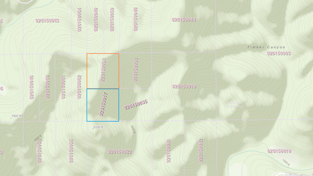
- Property ID: shasta orange (lepp)
- Property Address: Fenders Ferry Road, Montgomery creek, CA
- APN: 026-150-034-000
- GPS: 40.924601726152, -122.11917024308
- CCRs: none
- Association Fees: none
- Roads: dirt-4wd
- Power: No
- Water: no
- Sewer: no
- Seller Fees: 175
Owner financing available
Shasta National Forest
California mountain land
SIZE: 10+/- acres
APN#: 026-150-034-000 (orange parcel on the maps. NO PICTURES AT THIS TIME)
LEGAL DESCRIPTION: All that certain real property situate in the unincorporated territory of the County of Shasta, State of California, more particularly described as follows: PARCEL 2. THE NORTHWEST ONE-QUARTER OF LOT 10, SECTION 5, TOWNSHIP 35 NORTH, RANGE 2 WEST, M.D.B. & M. A NON EXCLUSIVE RIGHT OF WAY FOR INGRESS AND EGRESS AND CARRYING OF UTILITIES AS AN APPURTENANCE TO PARCEL 2 ABOVE, OVER AND ON A 60 FOOT STRIP OF LAND OWNED BY GRANTOR HEREIN. THIS EASEMENT TO BE FROM FENDER'S FERRY ROAD TO PARCEL 2 ABOVE AND ITS EXACT LOCATION SHALL BE GOVERNED BY GOOD ENGINEERING PRACTICES. AS AN APPURTENANCE TO PARCEL 2 ABOVE, GRANTEE IS HEREIN GIVEN A FISHING EASEMENT OVER AND ON SQUAW CREEK AS IT PRESENTLY MEANDERS THROUGH ADJOINING PROPERTY OF PREVIOUS GRANTOR. GRANTOR RESERVES a 40 foot road and utility easement on the existing road commencing East of the Southwest corner of the West one-half of the South one-half of lot 10 in Section 5, Township 35 North, Range 2 West, M.D.B.&M, and exits at the Northeast corner of The Northwest one-quarter of lot 10, Section 5, Township 35 North, Range 2 West, M.D.B.&M. with the right to assign this easement to additional properties in Section 5, Township 35 North, Range 2 West, M.D.B.&M.
STATE: California
COUNTY: Shasta
GENERAL LOCATION: about 25 miles NE of Redding
GPS (approx..): SE: 40.923956 , -122.117914 ; NE: 40.925885 , -122.117902 ; NW: 40.925861 , -122.12022 ; SW: 40.92394 , -122.12023
GENERAL INFORMATION: Mountain land. There is a cleared off spot on the ridge. (We do not know if this parcel was burned in the wildfires).
GENERAL ELEVATION: 2000'-2240'
TYPE OF TERRAIN: sloping
ZONING:
POWER: No
PHONE: No
WATER: No
SEWER: No
ROADS: dirt-4wd
PROPERTY TAX: TBD
CLOSING/DOC. FEES: 175
TIME LIMIT TO BUILD: none
ASSOCIATION DUES: none
Go to 1881.com
